

Crowdsourced mapping has become an integral part of humanitarian response, with high profile deployments of platforms following the Haiti and Nepal earthquakes, and the multiple projects initiated during the Ebola outbreak in North West Africa in 2014, being prominent examples. There have also been hundreds of deployments of crowdsourced mapping projects across the globe that did not have a high profile. This paper, through an analysis of 51 mapping deployments between 2010 and 2016, complimented with expert interviews, seeks to explore the organisational structures that create the conditions for effective mapping actions, and the relationship between the commissioning body, often a non-governmental organisation (NGO) and the volunteers who regularly make up the team charged with producing the map. The research suggests that there are three distinct areas that need to be improved in order to provide appropriate assistance through mapping in humanitarian crisis: regionalise, prepare and research. The paper concludes, based on the case studies, how each of these areas can be handled more effectively, concluding that failure to implement one area sufficiently can lead to overall project failure.
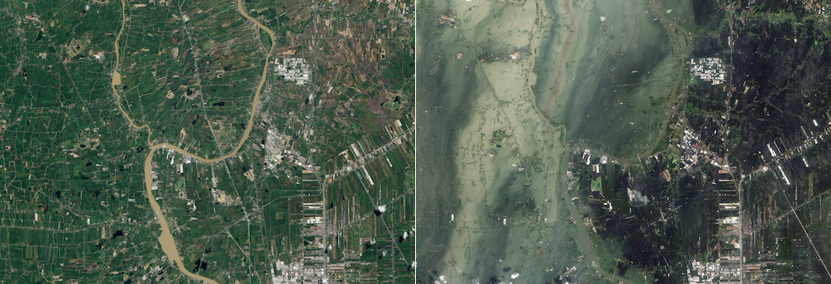
Picture: A pair of satellite images showing portions of Thailand’s Ayutthaya and Pathum Thani Provinces before (left), and after (right), a flood. NASA Earth Observatory image created by Jesse Allen and Robert Simmon, using EO-1 ALI data provided courtesy of the NASA EO-1 team and the United States Geological Survey
Introduction
The concept of crowdsourced crisis mapping is perhaps best defined as the provision of services by an international and/or online community, who gather, analyse and map critical information related to disaster-affected populations. Online digital responders often work as part of Volunteer and Technical Communities (V&TCs) which offer free, technical services during, and outside of, humanitarian activations (Capelo et al. 2012). While there have been several explorations of crowdsourced mapping (Walker and Rinner 2013; Meek et al. 2014) and digital humanitarianism (Burns 2015; Meier 2015), this paper considers the current landscape of crowdsourced crisis mapping and the relationship between V&TCs and formal humanitarian organisations. With crowdsourced crisis mapping becoming an ever more prevalent feature of emergency humanitarian response, the need for further research in this field is imperative. Thus far, existing literature has predominantly discussed the technology driving response mechanisms (Meek et al. 2014), with little detail on how technology has been adopted, nor the organisational strategies required to facilitate this. This paper focuses on the organisational nature of these projects, with attention paid to the collaboration between the technical and humanitarian fields, and the changing personal and organisational identities brought about by this global response mechanism.
This paper draws upon a series of high-level interviews to construct a broad impression of how these technologies, and their networks, have been mobilised across 6 years of crisis intervention (2010–2016). This approach seeks to understand the organisational structures required to effectively implement crowdsourced crisis mapping and highlight past points of failure. This research is predicated on two hypotheses, that (i) the context of crisis plays a more significant role than that assigned to it by V&TCs and that (ii) the current level of collaboration across organisations remains inconsistent and inadequate due to poor preparedness strategies for analysing and utilising crowdsourced data. The paper, firstly, provides context to the emerging field of crisis mapping, before examining existing literature. The methodology is then introduced in more depth, before providing an overview of results, alongside a discussion examining the above hypothesis. Finally, recommendations are provided for improvements to the field of crowdsourced mapping.
.


